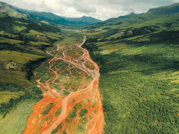
It was a cloudy July afternoon in Alaska's Kobuk Valley National Park, part of the biggest stretch of protected wilderness in the U.S. We were 95 kilometers (60 miles) from the nearest village and 400 kilometers from the road system. Nature doesn't get any more unspoiled. But the stream flowing past our feet looked polluted. The streambed was orange, as if the rocks had been stained with carrot juice. The surface glistened with a gasolinelike rainbow sheen. “This is bad stuff,” said Patrick Sullivan, an ecologist at the University of Alaska Anchorage.
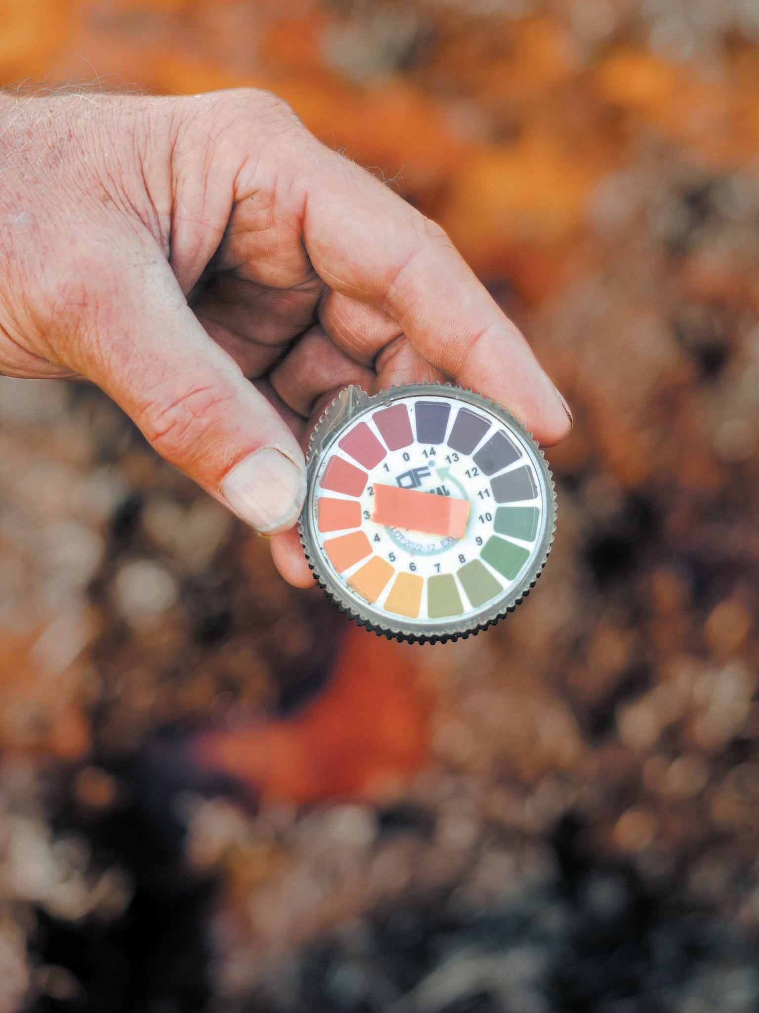
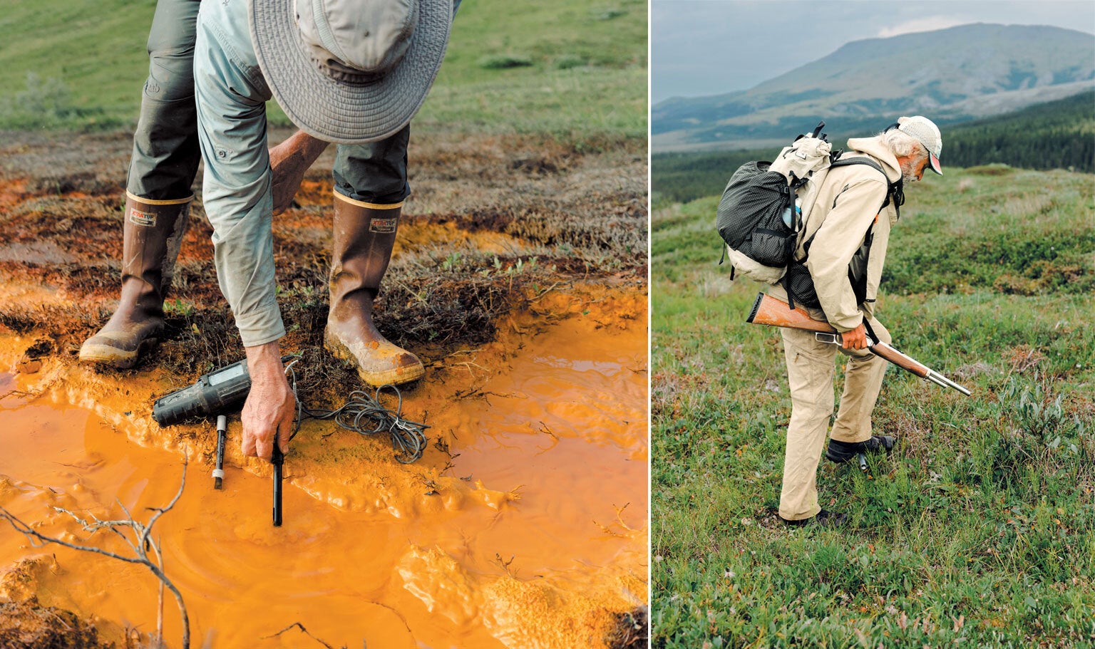
Sullivan, a short, bearded man with a Glock pistol strapped to his chest for protection against Grizzly Bears, was looking at the screen of a sensor he had dipped into the water. He read measurements from the screen to Roman Dial, a biology and mathematics professor at Alaska Pacific University. Dissolved oxygen was extremely low, and the pH was 6.4, about 100 times more acidic than the somewhat alkaline river into which the stream was flowing. The electrical conductivity, an indicator of dissolved metals or minerals, was closer to that of industrial wastewater than the average mountain stream. “Don't drink this water,” Sullivan said.
Less than a dozen meters away the stream flowed into the Salmon River, a ribbon of swift channels and shimmering rapids that winds south from the snow-dimpled dun peaks of the Brooks Range. This is the last frontier in the state known as “the last frontier,” a 1,000-kilometer line of pyramidlike slopes that wall off the northern portion of Alaska from the gray, wind-raked Arctic Coast.
One of the most remote and undisturbed rivers in America, the Salmon has long been renowned for its unspoiled nature. When author John McPhee paddled the Salmon in 1975, it contained “the clearest, purest water I have ever seen flowing over rocks,” he wrote in Coming into the Country, an Alaska classic. A landmark 1980 conservation act designated it a wild and scenic river for what the government called “water of exceptional clarity,” deep, luminescent blue-green pools and “large runs of chum and pink salmon.”
Now, however, the Salmon is quite literally rusting. Tributary streams along one third of the 110-kilometer river are full of oxidized iron minerals and, in many cases, acid. “It was a famous, pristine river ecosystem,” Sullivan said, “and it feels like it's completely collapsing now.” The same thing is happening to rivers and streams throughout the Brooks Range—at least 75 of them in the past five to 10 years—and probably in Russia and Canada as well. This past summer a researcher spotted two orange streams while flying from British Columbia to the Northwest Territories. “Almost certainly it is happening in other parts of the Arctic,” said Timothy Lyons, a geochemist at the University of California, Riverside, who's been working with Dial and Sullivan.
Scientists who have studied these rusting rivers agree that the ultimate cause is climate change. Kobuk Valley National Park has warmed by 2.4 degrees Celsius (4.32 degrees Fahrenheit) since 2006 and could get another 10.2 degrees C hotter by 2100, a greater increase than projected for any other national park. The heat may already have begun to thaw 40 percent of the park's permafrost, the layer of earth just under the topsoil that normally remains frozen year-round. McPhee wanted to protect the Salmon River because humans had “not yet begun to change it.” Now, less than 50 years later, we have done just that. The last great wilderness in America, which by law is supposed to be “untrammeled by man,” is being trammeled from afar by our global emissions.
But how, exactly, permafrost thaw is turning these rivers orange has been a mystery. Solving it is crucial for understanding what the sweeping ecological impact could be and to help communities adapt, such as the eight Alaska Native villages that depend on rivers in the western Brooks Range for fish and drinking water. Some researchers think acid from minerals is leaching iron out of bedrock that has been exposed to water for the first time in millennia. Others think bacteria are mobilizing iron from the soil in thawing wetlands.
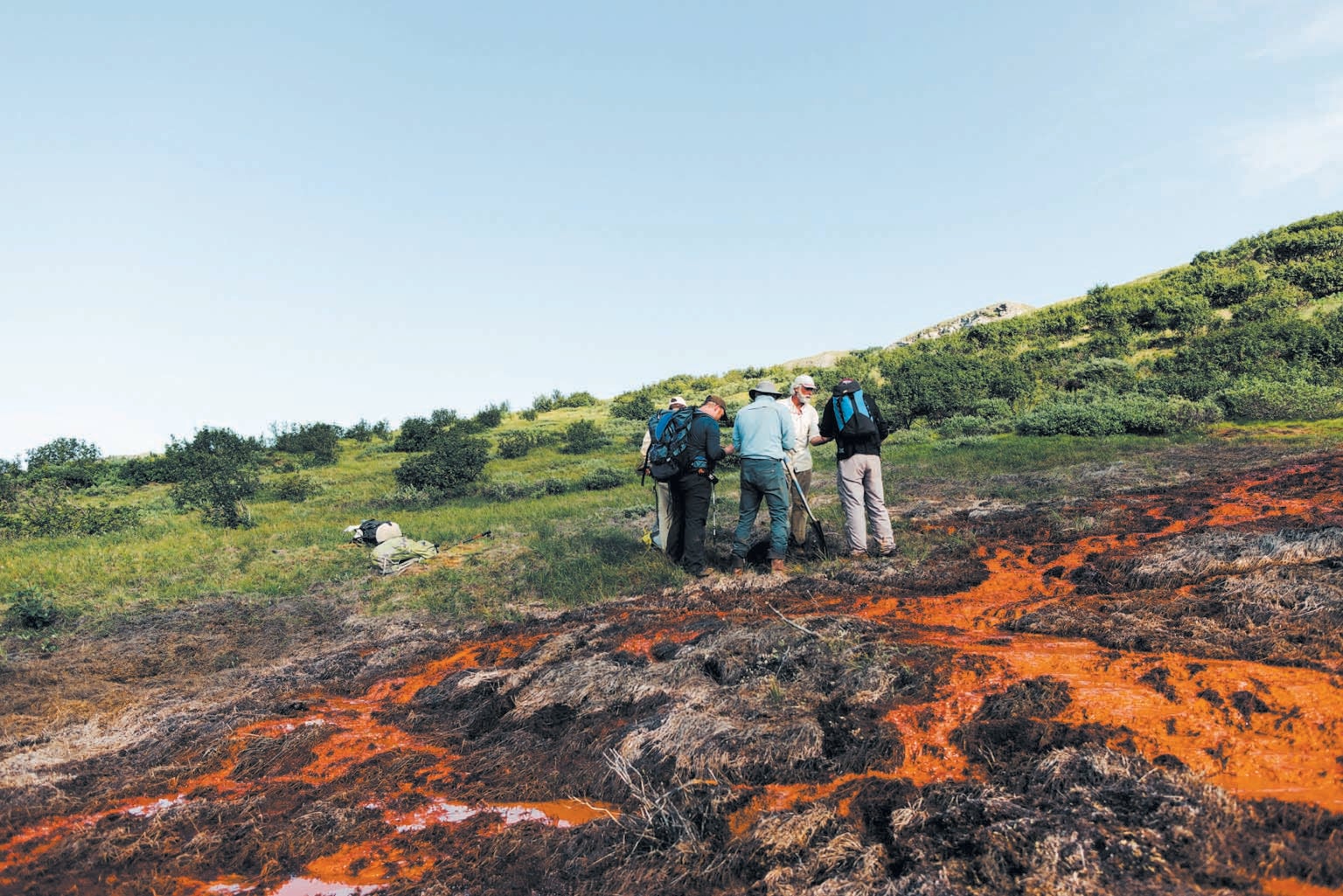
I had joined a group of scientists and wilderness buffs for a six-day trip down the Salmon to try to figure out which, if either, of these hypotheses explained the pollution in this once spotless waterway. We'd paddle downriver about 25 kilometers a day, passing from the treeless tundra near its headwaters to the boreal forest at its confluence with the broad, sluggish Kobuk River, then follow the Kobuk to the nearest village. Along the way we'd stop at as many tributaries as possible to take notes, collect vials of water and pick invertebrates off the rocks for the first comprehensive sampling of an entire rusting watershed. If the acid-rock hypothesis proved true, the fish downstream of certain mountains could be in lethal danger. If the bacteria hypothesis was right, the rusting could gradually smother streams almost anywhere there's permafrost—an area that includes about one fourth of the Northern Hemisphere.
To get close to the Salmon, two graduate students and I took a six-seater bush plane inland from the Arctic coast. The ice close to the Salmon had broken up in late spring, so any gravel bars on the river where a fat-tired bush plane might land were still under water. The best the pilot could do was to land on a long, flat gravel ridge in the mist-covered mountains north of the river. The rest of the group, who had been taking data in another watershed, was waiting there for our cargo of inflatable pack rafts, paddles, personal flotation devices, food and 52 water-sampling kits. We strapped the rafts, which folded down to the size of a gallon of milk, to the top of each pack for the hike to the river.
“This is the heaviest my backpack has ever been,” graduate student Maddy Zietlow said before we powered through 20 kilometers of windswept ridges, ankle-twisting tussocks and scratchy brush. We finally descended toward the luminescent braids of the Salmon to camp for the night as half a dozen white-coated Dall Sheep bounded away over a ridge.
The highest reaches of the Salmon still have clear water, but they're too rocky and shallow to float on, so the next morning we sloshed a few kilometers down the nascent river until we found a spot deep enough to launch our pack rafts. We stuffed the food and gear into oval storage tubes in the rafts and blew them up taut. During the first few kilometers of paddling, we had to lift our butts off the bottom of the rafts to keep from getting stuck every time the current scraped us over a ledge of rapids. We dodged aquamarine marble rocks the size of couch cushions.
When McPhee was here, he wrote that the river was so clear and full of fish that “looking over the side of the canoe is like staring down into a sky full of zeppelins.” These days, however, looking over the side is like staring down into a sky full of thick haze. An hour downstream from where we embarked, a large tributary called Kanaktok Creek was pumping in murky water over orange rocks, turning the Salmon green. The next incoming stream was so full of iron that the main stem ran half orange and half green. For the rest of the trip the river had the color and opacity of pea soup. “Most climate change is subtle,” said Forrest McCarthy, a former U.S. Antarctic Program field-safety coordinator, who was helping with water samples. “This is like, bam!” he continued, snapping his fingers.
The first investigators to document the rusting rivers were U.S. Geological Survey and National Park Service personnel studying how permafrost changes in the Brooks Range are affecting fish such as the Dolly Varden, a big, silvery green char with red spots that local villages prize above all others. In August 2018, when biologist Mike Carey flew by helicopter to retrieve a water sensor he had left in a clean stream east of the Salmon, he saw that the bottom was blanketed in orange slime. He couldn't find any fish or insects. “Biodiversity just crashed,” he recalled.
Carey thought the weird situation was a one-off until the following July, Alaska's hottest month on record. The Agashashok River, 96 kilometers west of the Salmon, turned from turquoise to orange-brown along part of its course. In the winter of 2019 the snowpack was abnormally high; that can insulate the ground, further encouraging permafrost thaw. Then came another hot summer and another snowy winter, and the rusting spread.
Dial and Sullivan, who had been studying the northward march of the tree line in the warming Brooks Range, were shocked by how fast streams there started transforming. On one 2020 expedition the water in a stream called Clear Creek was so acidic it curdled the powdered milk Zietlow used for her nightly tea. A loose network of interested scientists began to coalesce. For Dial, a kind of wilderness beatnik with a face of white stubble and a stream-of-consciousness manner of speaking, the expanding project was personal: he had been climbing mountains and floating rivers in the Brooks Range for more than 40 years. “It's fascinating from a scientific point of view, but from an emotional point of view, it's sad,” he said of the changes he's witnessing. “The alarming thing is how far our human reach is, in a big way.”
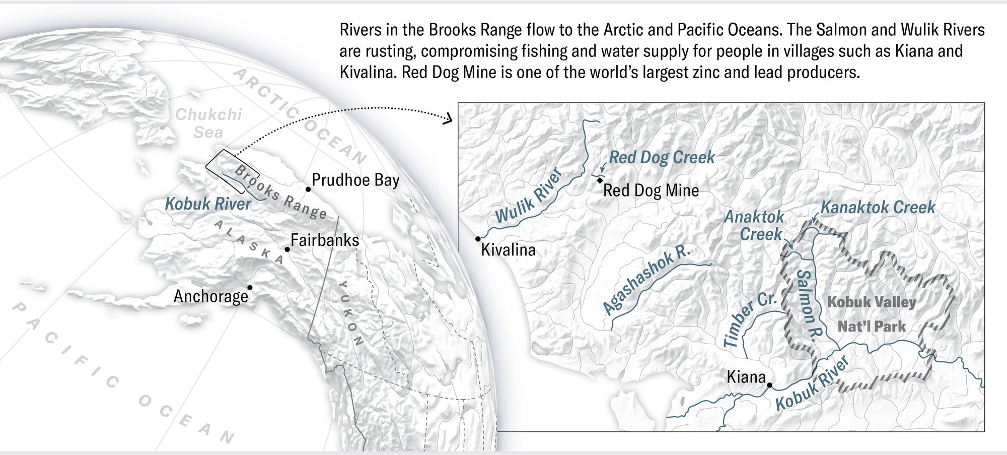
Rivers in the Brooks Range flow to the Arctic and Pacific Oceans. The Salmon and Wulik Rivers are rusting, compromising fishing and water supply for people in villages such as Kiana and Kivalina. Red Dog Mine is one of the world’s largest zinc and lead producers. Credit: Daniel P. Huffman
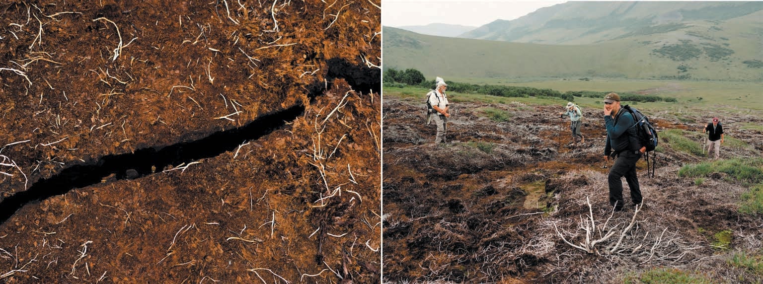
After about four hours on the water, we came to a wide bend where the river looked as if it were disappearing into a tunnel. The current had eaten deep into the softening shore, creating an overhang of earth at least 30 meters long. Muddy roots hung down like strands of a beaded curtain. Globules of watery dirt plopped into the river, and the air smelled like a mix of moldy towels and rotting vegetables—the unmistakable scent of thawing permafrost. “I don't remember that,” Sullivan said, frowning.
Permafrost ranges from isolated patches in Anchorage to a near-continuous sheet in the Brooks Range. If you set a fire and then dug down into the warmed area like gold miners did, under about a meter of seasonally thawed topsoil you'd find ground as hard as concrete and as many as 600 meters deep in places like Prudhoe Bay, much of which has been frozen since the last ice age. Within that layer is animal and plant matter holding twice as much carbon as the atmosphere does. When permafrost thaws, microbes begin to digest this matter and emit carbon dioxide and methane; that rotting-vegetable smell means the planet is cooking.
The ice contains other surprises as well. In Russia in 2016, anthrax reactivated by permafrost thaw led to the death of a 12-year-old boy. The softening earth could also unleash viruses, chemicals or mercury, a recent study warned—a Pandora's icebox of unexpected consequences. Still, the rusting of rivers blindsided the Alaska scientists. They suspected that the thaw was driving it, but they weren't sure how. Then David Cooper, an ecologist at Colorado State University, suggested what they now refer to as the “wetlands hypothesis”—the idea that microbes in the soil are producing not just methane but also soluble iron.
Cooper has known Dial since 1979, when, as a teenage climber, Dial wandered into Cooper's research camp in the Brooks Range soaked, freezing and hungry. He gave the young Dial warm clothes and food, perhaps saving his life. In 2021 Dial invited Cooper on a research trip to Timber Creek, 30 kilometers west of the Salmon. On the first day Cooper tried some fly-fishing and found more iron than fish. “I looked at the creek,” he recalled, “and I said, ‘This creek is dead. It's just blanketed with metals.’”
He wondered whether bacteria might be to blame. The chemical process of breaking down carbon compounds for energy produces hydrogen atoms with an extra electron each. Many bacteria rely on oxygen molecules to accept that extra electron in a process known as reduction. But in waterlogged environments, where there is no free oxygen, bacterial respiration can reduce other elements, such as sulfur, or it can reduce the oxidized iron that, along with organic matter and manganese, gives soil its brown color.
The thaw of permafrost soil under a wetland allows bacteria to start reducing that oxidized iron, Cooper thinks. And reduced iron, unlike oxidized iron, is soluble in water. If it's carried by groundwater out into an oxygenated stream, it can once again be oxidized. When that happens, it will fall out of the water as “rust” and turn the stream orange. While digging trenches on marshy ground near Timber Creek this past August, Cooper and Dial found water as deep as 1.5 meters under the once frozen soil, as well as dirt the gray color of reduced iron. New groundwater flows have developed in the thawing earth, Cooper said, and they have “really awakened a lot of these geochemical processes that have been basically stalled out for 5,000 years because the ground's been frozen.”
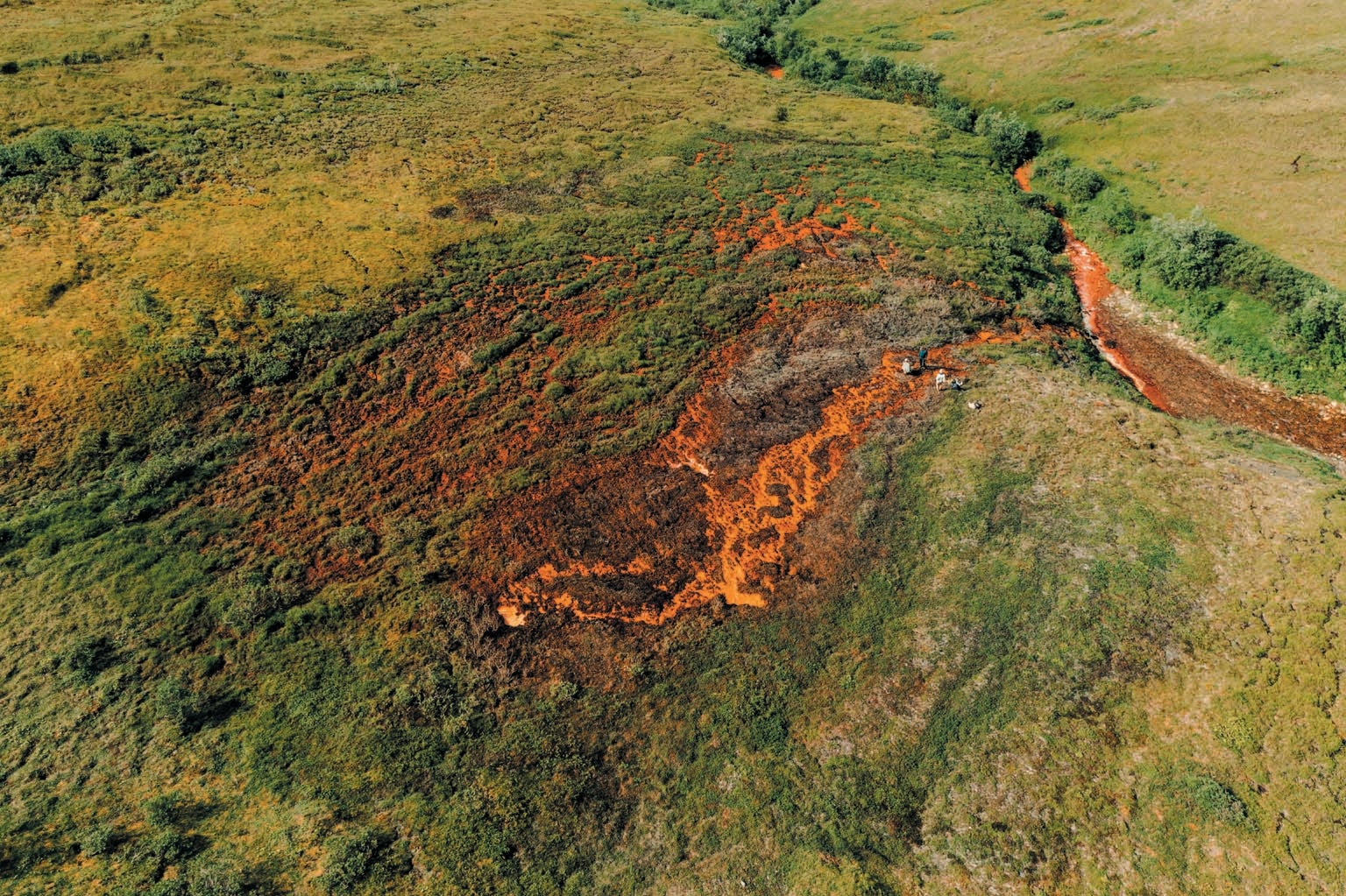
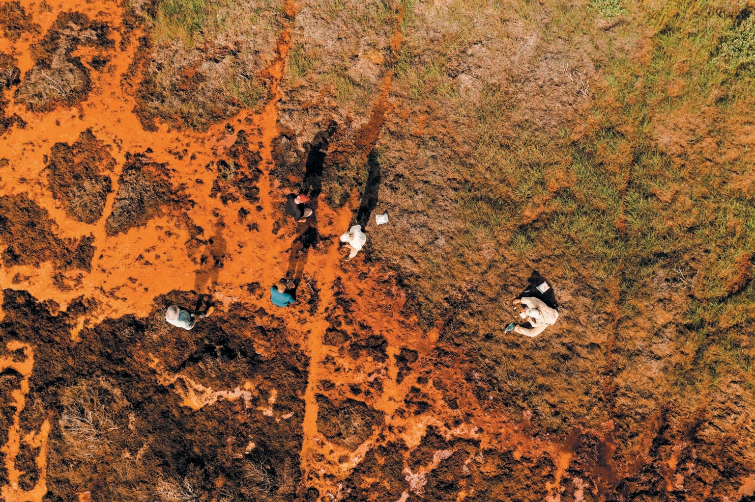
The second night, we camped among spindly spruce trees on the gravel shore across from where Anaktok Creek, a toxic orange tributary, runs through a long, winding valley and into the Salmon. Dial and Sullivan, who knew the Anaktok from previous trips, wanted to hike half a dozen kilometers up into the valley and float back down, sampling the creek and the tiny streams that feed it. The next morning we grabbed several water-sampling kits each, paddled across the river, packed up our rafts and started up the northern slope. As we got higher we could see across to the southern side of the valley, and we discovered a startling sight. An expanse of green tundra maybe 100 meters long looked as if it had been burned—only there hadn't been any wildfire.
We scrambled up a hill and began moving along the broad ridgeline, and after more than an hour we came across an ugly black sore on our side of the valley. Twigs of dead lingonberry and dryas shrubs drooped onto dirt the color of fresh asphalt. A channel of water trickled out of the dark ground. It was too shallow to measure with the sampling kit, so McCarthy offered to sacrifice his Nalgene water bottle. He took one last swig and dumped its contents, then slowly refilled it from the seep. When Sullivan dipped a sensor into the bottle, it showed a pH of 2.95, like vinegar. The burn was from acid. “If it's got that low of a pH ... it's actively burning,” Sullivan said. “There's at least a dozen burns in this valley,” Dial added.
We stumbled on another burn among the raking willow shrubs as we descended toward the creek, and the trickle from the lumpy black crust there was strongly acidic, too. Below the black spots, an orange slime covered the rocks of the Anaktok, rubbing off on the hands of Alexander Lee, an Alaska Pacific University philosophy professor who was helping to sample fish and invertebrates. A small stream coming down from the hills had a highly acidic pH of 3.5. “Wow, this is crazy,” Dial said.
“And not much rust. It's probably still in solution,” Sullivan said. Although the wetlands hypothesis offered a reason for the orange staining, it couldn't explain the acidification. In late 2022 Lyons had contacted Dial with the idea that water was reacting with minerals in the bedrock—the “acid-rock drainage hypothesis.” He had seen a web article with a photograph Dial had taken of the Salmon in autumn, as bright yellow as the Balsam Poplar trees next to it, and he was reminded of research he'd done for NASA on Spain's infamous Rio Tinto, which is so orange and full of acid from upstream mining that it's considered a potential analogue for acidic sites on Mars.
Most ore deposits are rich in sulfide minerals such as pyrite (“fool's gold”), a compound of sulfur and iron. If a sulfide mineral is exposed to water and oxygen, as will happen when miners start breaking up rock, the sulfur splits off the metal and bonds with hydrogen and oxygen molecules, forming sulfuric acid. The resulting contamination by acid and metals, including iron, is a problem in flooded mines and in ponds full of tailings (the waste product from processing mined ore) around the world. Acid-rock drainage can also happen naturally when streams weather sulfide rock in ore deposits. Alaska Natives have spotted occasional orange streams around the Brooks Range for years—though not in the numbers appearing now. Lyons thinks permafrost thaw is lifting the icy lid off the bedrock, allowing oxygenated water to reach pyrite-rich shale for the first time in thousands of years. That's forming sulfuric acid and oxidizing the leftover iron, which would normally precipitate out of the water as rust. The acidity dissolves the oxidized iron, allowing it to flow with the ground seep just as reduced iron does.
But the Brooks Range also happens to have a lot of alkaline limestone, which makes water more basic. If the acidic water from a seep reaches an alkaline river or stream, its pH will rise, and the iron will fall out as what miners would call yellow boy. “It's like a one-two punch,” Lyons said. “You have the shaley rocks with pyrite that source the acid and the iron, and then the limestones neutralize that acid and cause the iron to come out of solution.”
What's really scary is that the acid might also be leaching out other metals, such as copper, zinc, cadmium, lead and even arsenic, that are then carried far downstream. Mining areas often hold enough sulfide minerals to fuel these reactions for millennia. Hillside seeps from permafrost might “turn on” only in years of greater thaw, or they could continue for decades or centuries. “That's why this problem is so challenging from a remediation point of view,” says Brett Poulin, an environmental toxicology expert at the University of California, Davis. “As long as you have water and oxygen and there's still a mineral, it will just keep going.”
For the next two days we kept paddling and sampling tributaries as hills coated only by low groundcover gave way to lowlands of teeming conifers. The Salmon, widening, seemed almost devoid of fish, and the sky was eerily free of birds. After three days of trying, Lee, the philosophy professor, caught only one Dolly Varden, coring a small tissue sample from its polka-dotted side to test it for metals.
The murky water started to clear slightly; clean tributaries were diluting the colored flows. But on our second-to-last day, just before the Salmon joined the Kobuk River, we found the ugliest stream yet, coming out of a marshy woodland. It was more a hideous maroon than orange. Almost like an ooze, it clogged the filter of the water-sampling kit. Saplings along the bank had been chewed by beavers, which have been moving north with the advancing tree line, their ponds further thawing the permafrost. “It's a massive wetland,” Dial said after paddling partway up the stream. “I think what we've got is the wetlands hypothesis.”
We pulled into the Alaska Native village of Kiana on the Kobuk at 3:00 A.M. on our final day. By that time we had rafted more than 145 kilometers and sampled more than 20 streams, but we still hadn't solved the mystery. There appeared to be evidence for both hypotheses. In the “valley of the burns,” permafrost thaw seemed to be allowing water to leach iron out of the bedrock, which turned our campfire discussions toward the acid-rock drainage hypothesis. Around the ugly stream, though, it was more likely that permafrost thaw was activating iron-reducing soil bacteria, as the wetlands hypothesis would suggest. In many places, both mechanisms are probably playing a role.
Although the Salmon is a good place to investigate these interactions, it's relatively far from human habitation, and its effluent gets diluted by the massive Kobuk. But as the rusting metastasizes to other rivers in the Brooks Range, it threatens to harm settlements, first and foremost the coastal town of Kivalina.
Like the Salmon, the Wulik River flows down from the Brooks Range, and many of its tributaries have been turning orange. The difference is that at the mouth of the Wulik there is a village, Kivalina, whose 444 residents rely on the river for water and fish. Small changes in water quality could have significant consequences for them.
I flew in a small airplane to the shrinking barrier island north of the Bering Strait where Kivalina is located, about 160 kilometers northwest from where our paddling had ended. The first things I saw on arrival were crosses marking graves on the narrow strip of land along the runway. Behind that was the lagoon where the Wulik empties into the sea.
The next evening Jared Norton, a 25-year-old in a Los Angeles Dodgers cap and white hoodie, pulled up a fishing net across the bow of an aluminum boat, a drizzling rain falling across the lagoon. Like many residents, Norton spends a lot of his time hunting and fishing. The first few fish were silvery Chum Salmon, also known as dog salmon because they're the primary pet food in Alaska Native villages. Then a big fish with a turquoise back and sides came into view. “There's the one I'm looking for!” Norton said. “There is the one I need.” It was a Dolly Varden.
Dolly Varden are a big part of Kivalina's way of life. They're also likely to be the first fish affected by rusting rivers. Chum Salmon leave freshwater for the ocean days or weeks after emerging from the streambed and return only at the end of their life, but Dolly Varden take years to make it to the sea. Once they do, they return to rivers and lakes every year to overwinter. Some “residents” never leave freshwater at all. As a result, they're more exposed to changes in the streams.
A mature Dolly Varden is green with red spots—a beautiful fish, even more striking than its cousin the Brook Trout. The name comes from a Charles Dickens character who beguiles men with her cherry-colored clothes or, more likely, from a red polka-dot fabric inspired by her. Anglers will pay thousands of dollars to fish for one in the Wulik, where a 12-kilogram world-record breaker was caught in 2002. Alaska Natives value the Dolly for its flavorful orange flesh. They say Kivalina's Dolly Varden “taste the sweetest” of all, especially after they've been left to age for two weeks along the shore. Residents trade bags of fish with northern villagers for blubber and with southern villagers for venison.
Norton put the Dolly Varden in a metal bucket to take home to his mother. After a few more Chum, a second Dolly came up in the net. This one was smaller, with a reddish mark on its pale belly, like a wound that had healed. Norton hurled it back into the lagoon.
Kivalina is a hard place. With no plumbing, residents have to haul water in barrels. Several houses—prefab wood structures built on short stilts—are cracking as the land sinks and gets eroded, weakened by the melting of sea ice above and permafrost thaw below. Hoping to eventually get enough funding to retreat from the sea, the village has built a school 13 kilometers inland. The “evacuation road” leading to it is already cracking in places from thaw.
Like several other Alaska Native villages, Kivalina depends on rivers flowing out of the Brooks Range for fish and drinking water. For hundreds of years seminomadic Inupiat people came here in the spring to go after northbound whales, then moved inland to hunt Alaska's largest caribou herd as it headed south in the fall. They relied on late-autumn Dolly Varden to get through the nine months of cold.
The people here have managed to keep these hunting and fishing traditions alive despite forced settlement, Christianization, devastation of the whales and a long succession of epidemics. To this day, four fifths of their food come from the land and sea—now via snowmobile and motorboat. But tributaries of the Wulik have begun rusting, possibly jeopardizing the Dolly Varden. “It would be a real big hurt on us,” says Replogle Swan, president of the Kivalina Volunteer Search and Rescue. “That fish is just a part of our lives.”
Iron and other metals can starve fish by smothering invertebrates they eat, such as mayflies, and fish eggs could suffocate if the streambed is covered in iron. Researchers have found that iron and aluminum on fish gills hinder respiration. Cherelle Barr, a mother of two who works for the regional native corporation, fishes rod and reel for Dolly Varden every fall at her family's cabin near the mouth of the Salmon River. Of the 30 Dollies they caught last year, about 10 were deformed, she said. Some had big bumps on their back; others had pus behind their gills. Even bears on a small island in the river were wary. “You could tell they were not eating the [fish] that had that stuff by their gills” or the ones that were deformed, Barr said. The pus could be caused by a parasite or disease, but it is concerning. State scientists who track fish have seen them avoid streams with elevated iron, manganese and acidity.
Since 1989 Red Dog, one of the world's largest zinc mines, has been fundamental to the region's economy. Every year after the ice starts breaking up, the mine, 64 kilometers inland, discharges treated wastewater into Red Dog Creek, which flows into the Wulik and to the sea. Kivalina residents accuse the mine, which in the past has been found guilty of violating the Clean Water Act, of spoiling their water. Some people haul drinking water by boat from another nearby river rather than filling up at the tank supplied from the Wulik.
In some ways, however, Red Dog Creek got cleaner after the mine opened because the creek was a natural source of acid-rock drainage before the mine was there. In fact, the creek's orange color was what led a bush pilot to report the likelihood of valuable minerals there in the 1960s. Concentrations of heavy metals downstream declined after the mine installed pipes to divert Red Dog Creek and other streams around the ore deposits, according to annual monitoring by the Alaska Department of Fish and Game. The creek also became less acidic. At the same time, the concentration of “total dissolved solids” increased, mainly because of sulfates and calcium hydroxide the mine was adding to remove metals from the wastewater.
During the hot summer of 2019 the concentration of total dissolved solids downstream rose so much it reached the limit set by Red Dog's permit, forcing the mine to stop discharging its wastewater into the creek for more than a year. The problem was that creeks upstream of the mine were beginning to rust, feeding milky yellow water into the Wulik. Red Dog couldn't start discharging again until it built a $19-million reverse-osmosis treatment system that released cleaner wastewater.
Since then, more streams above the mine have turned orange because of permafrost thaw, Fish and Game says. Total dissolved solids have continued to rise despite the treatment system. “Fish swimming in or through this water would not probably die right away, but it is a chronic stressor,” says Brendan Scanlon, a biologist with Fish and Game in Fairbanks.
Permafrost has become a bigger polluter than the mine, and not much can be done to clean up the problem. Lime is often dumped into tailings ponds at old mines to buffer acid, but you can't “lime” an entire mountain stream, just as you can't refreeze the ground around it. Perhaps the only real hope is that once all the permafrost has thawed and all the iron has rusted, these wild rivers will be able to flush out the contamination and restore themselves, although that would take decades at least.
When we were floating the lower Salmon, in the round-the-clock sunshine of the Arctic summer, I had asked Dial what still fascinated him about the Brooks Range after all these years. He replied that it's how much the vast ecosystem here is changing but also how it has the power to heal. “It's resilient,” he said. Given enough time, he hoped, the wilderness might prove “big enough to clean itself up.”
This story is part of the Pulitzer Center's nationwide Connected Coastlines reporting initiative.